Send the link on. In chat and email, the article title and photo show up with it.
https://mostlyharmless.travel/articles/coventry
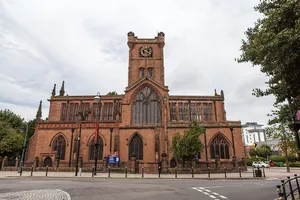
Broadgate and Precincts Taken from the tower of the old cathedral church of St. Michael, looking westwards down the line of the Upper and Lower Precinct shopping areas towards Mercia House[1], the tower block at the bottom end of the Lower Precinct. To the right of Mercia House is the red sandstone tower of St John's Church. To its left a little further into the distance is the Skydome and Odeon complex in Spon Street, partially obscured by the blue blob of Ikea. The grey tower block to the left is Coventry Point in Market Way. In the foreground is the roof of the Cathedral Lanes shopping centre swamping Broadgate. Left foreground is Pepper Lane, running towards High Street. To see how it looked in 1975, see https://www.geograph.org.uk/photo/156892 and 1983 : https://www.geograph.org.uk/photo/1059854 .
Author: E Gammie, License: CC BY-SA 2.0
·
Source
Registration is currently only possible with an invite code. Please enter your invite code or use your personal invite link. If you don't have a code, you can request one from us.
 alpha
NOW FEDERATED!
alpha
NOW FEDERATED!
![Broadgate and Precincts Taken from the tower of the old cathedral church of St. Michael, looking westwards down the line of the Upper and Lower Precinct shopping areas towards Mercia House[1], the tower block at the bottom end of the Lower Precinct. To the right of Mercia House is the red sandstone tower of St John's Church. To its left a little further into the distance is the Skydome and Odeon complex in Spon Street, partially obscured by the blue blob of Ikea. The grey tower block to the left is Coventry Point in Market Way. In the foreground is the roof of the Cathedral Lanes shopping centre swamping Broadgate. Left foreground is Pepper Lane, running towards High Street. To see how it looked in 1975, see https://www.geograph.org.uk/photo/156892 and 1983 : https://www.geograph.org.uk/photo/1059854 .](/images/articles/82/l/82bb5feef418260cd72164e097f0e2f1.webp)